By Gabrielle Canon and Cecilia Nowell • June 12, 2026 • Environment
Experts say climate pattern could supercharge extreme weather events and push temperatures to record highs
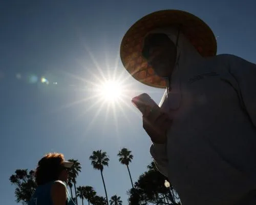
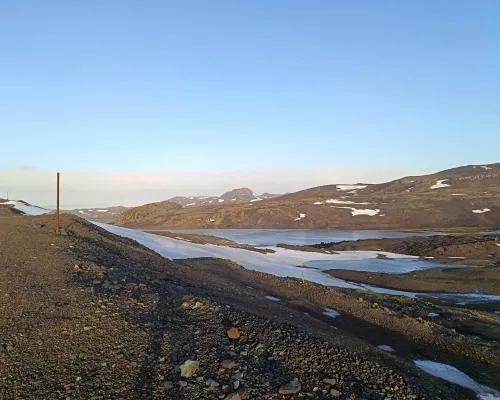
EL Niño has officially arrived, US officials at the National Oceanic and Atmospheric Administration (Noaa) said on Thursday, and scientists predict it could be the strongest of the century. Forecasters had previously anticipated that a phenomenon known as a super “El Niño” would emerge this summer – supercharging extreme weather events and pushing global temperatures to record heights. There’s a high probability that this year’s El Niño, which is expected to peak in the fall or winter, “would rank among the largest El Niño events in the historical record going back to 1950”, according to Noaa. A strong El Niño would put 2027 in the running to break global heat records, and could produce a series of devastating effects, ranging from supercharged rainstorms to drought, depending on the region of the world. Here’s what you need to know: What is El Niño? The ocean and the atmosphere are inextricably linked. That’s why forecasters look closely at ocean temperatures and conditions to help predict future weather patterns around the world. El Niño is characterized by warming of the ocean surface in the central and eastern tropical Pacific Ocean. It’s one of three states scientists observe; La Niña, conversely, happens when sea surface temperatures are below average, and neutral conditions are defined when neither El Niño or La Niña are present and surface temperatures are about average. These three states together form the “El Niño-southern oscillation” (Enso), which tends to develop during spring in the northern hemisphere and shifts every three to seven years, according to the US National Weather Service. Warming and cooling at sea surface during El Niño and La Niña can range from 1C to 3C, and have enormous effects on precipitation, drought, heat and climate disasters in different regions. During Niño years, the winds that would push warm waters to the west soften or shift direction, enabling the surface waters in that part of the Pacific to warm. Characterized by temperatures at least 0.5C above the norm, these conditions hugely affect the weather and often push global temperatures to new heights. Climate scientists are quick to point out that each event is unique and there’s considerable variability between them, in intensity and outcomes. But Enso predictions can help people around the world prepare for coming shifts in extreme weather – an essential tool in a warming world. How does El Niño affect weather events? While there are many factors that drive weather, El Niño can create a huge atmospheric upset. It alters jet streams and flips precipitation patterns, fueling more severe storms in some parts of the world, while desiccating others. It also has the power to spike rising temperatures even higher, at least briefly. A super El Niño that occurred in 2015 brought severe drought in Ethiopia and water supply shortages in Puerto Rico, and smashed records after unleashing a vicious hurricane season in the central north Pacific, according to an analysis by US federal scientists. The cycle tends to create drought and heat across Australia, around southern and central Africa, in India and in parts of South America, including in the Amazon rainforest. Heavy precipitation, meanwhile, could hit the southern tier of the US, parts of the Middle East, and south-central Asia. Why are scientists talking about a ‘super El Niño’? A “super” El Niño just means one that is stronger. Even before it officially formed, this El Niño has acquired nicknames ranging from “super” to “Godzilla”. These are rare events typically defined by sea surface temperatures spiking up by at least 2C. This has only occurred a few times since 1950 and only once have temperatures surged past 2.5C. The higher they go, the higher the likelihood that impacts from El Niño would be supercharged. There was a 63% chance that this El Niño will get so intense by late fall and early winter that it “would rank among the largest El Niño events in the historical record going back to 1950”, according to Noaa. Dr Paul Roundy, a professor of atmospheric and environmental sciences at the State University of New York at Albany, wrote in April that there was “real potential for the strongest El Niño event in 140 years”. Dr Andy Hazelton, associate scientist at the University of Miami, wrote: “All models and observations are pointing in the same direction: a very strong El Niño with significant impacts on global climate this year.” What does this mean for 2027? “Every El Nino is not the same; each one is unique with its own imprint on our weather,” Ken Graham, the director of Noaa’s National Weather Service (NWS), said in a statement. In the United States, El Niño’s impacts are felt differently region to region. In the south, it’s historically caused stormier weather. While on the west coast, it’s associated with a wet winter, high tide flooding and algal blooms. On the east coast, it’s often dampened Atlantic hurricane season, while boosting hurricane activity in the Pacific. In the northern Rockies and south-west – which are experiencing a severe snow drought – El Niño can produce strong summer rains. Although its effects could vary, forecasters agree that the 2026-2027 season could see one of the largest El Niños in modern history. “The most recent El Niño, in 2023-24, was one of the five strongest on record and it played a role in the record global temperatures we saw in 2024,” Celeste Saulo, the World Meteorological Organization secretary general, said in a written statement. The El Niño weather pattern typically occurs every two to seven years, and lasts nine to 12 months. Deluges could come as a welcome relief for thirsty states in the US hoping water supply shortages caused by this year’s dire snowpack might be bailed out by a strong summer monsoon and wetter winter next year. But as Tom Di Liberto, the climate scientist and media director for Climate Central, said at a media briefing in April, these dry conditions have largely been fueled by heat, and it’s less likely that these regions will get a reprieve from rising temperatures. Experts have also said that, most devastatingly, dry water basins won’t be able to rebound after one wet season. That’s particularly true in the US south-west, where some reservoirs are at an all-time low. “Just because we’re expecting a large-scale change in the climate pattern doesn’t necessarily mean that we’re going to see drought completely erased,” Dr Joel Lisonbee, senior associate scientist at the Cooperative Institute for Research at the University of Colorado Boulder said. “It would have to be exceptionally wet,” he added. “That would also mean flooding, and the destruction and potential loss of life that comes along with that.” Dani Anguiano and the Associated Press contributed reporting
Source: The Guardian
Green News
52 posts
-
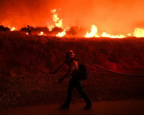 El Niño forms in Pacific as experts say it will likely turbocharge extreme weather
Meteorologists predict it will be the strongest of century, while UN secretary-general calls it ‘urgent climate warning’
-
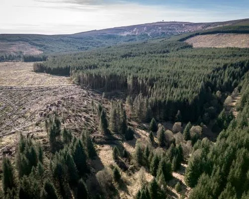 Commercial forests and biodiversity claims
Letters: Paul Brannen extols the benefits of commercial forestry, while Dr Andrew Cameron warns of Britain ‘offshoring’ its timbers supplies, and Jane Gifford calls on the Scottish government to review its forestry policy
-
 Bananas could vanish from school lunch menus. Here’s why
New Farm Bill places caps on non-US foods; nutritionists say it restricts availability of healthy meals for kids
-
 Rare great white shark briefly hooked off Nantucket beach in catch-and-release encounter
Footage shows Elliot Sudal hauling the shark from the surf before releasing it within seconds, sparking online reaction
-
 Country diary: A tiny orchid with mighty powers of deception
Wolstonbury Hill, West Sussex: The fly orchid looks like no fly I’ve ever seen – its target insect is a wasp. Even more strange is that neither I (nor Charles Darwin) have ever seen one being pollinated
-
 Millions of homes in London, Essex and Kent at risk of sinking as climate crisis worsens
Analysis pinpoints areas most vulnerable to hotter, drier weather causing ground to shrink and drag foundations down
-
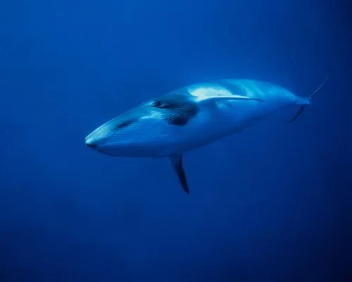 Deepest and most extensive whale graveyard discovered in Indian Ocean
Some remains found in Diamantina fracture zone date back more than 5m years and reveal species and ecosystems unknown to science
-
 Record winter temperatures in Antarctic raise fears over speed of climate breakdown
Temperatures above 15C ‘very strange’ say scientists, as snow melts and rain falls on glaciers in usually frozen region
-
 When is rare good news on climate science actually bad? When News Corp misrepresents it
The worst-case scenario for a high-emissions scenario has been revised downward – but the best-case option is now implausible
-
 Link between poverty and access to nature
Letter: Prof Kathy Willis responds to research showing that the poorest areas in the country face the deepest cuts to green spaces


